Technologies based on Artificial Intelligence applied to territorial analysis.

What is the Artificial Intelligence?
The artificial intelligence (AI) is the simulation of the human intelligence’s processes made by machines. These processes include the learning (the acquisition of information and rules), the reasoning and the self-correction.![]()
GRAFCAN has started to develop several pioneering and innovative lines of work, which develop technologies based on Artificial Intelligence. These technologies applied to territory, are complementing, extending and strengthening the company’s capacity on spatial data analisys. Actual projects:
Resumen – Presentación – Revista MAPPING
Aerial images change detection using Deep Learning
GRAFCAN has reached recently a pioneering and innovative technological development, that allow us to detect automatically changes in the territory from Orthophotos (rectified aerial images).
The GRAFCAN’s developed project is focusing on the changes produced in the road network and buildings. Its aim is to identify not only new roads and buildings but also changes and alterations in the existing ones.
The project began in 2016, as an internal activity of R&D with partial dedication of technical resources. The developed software is based on ‘TensorFlow’ AI framework, which is developed by Google for Machine Learning. The GRAFCAN’s work has mainly focussed on the definition and evaluation of different arquitectures of deep neuronal networks and in the creation of tools, which are able to produce training patterns for those networks.
The trainning patterns are the basis for the learning process and the later behaviour of the networks. Patterns are pairs of images which indicate whether or not there is a change and which basic clasification will have. The developed network consists of 22 neuronal layers with more than 36 millions of parameters to be adjusted during the training processes. We are using more than 85.000 patterns on the training processes.
The developed neuronal network shows a great operating efficiency. For instance, in the case of Lanzarote Island, it is able to analize its 27.000 millions of pixels that are included in two images of the island (previous and later ones) at 25 cm/pixels resolution, taking less than 48 hours long to obtain the result of 823 changes. This performance has been improved by several software optimizations and specialized hardware (GPU).
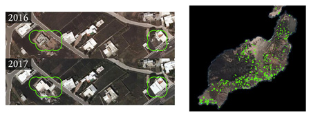
Taking into account that the network’s behaviour is determined by the process of learning and this is based on a partial subset by definition, which represents all the cases in real life, it has been decided to check the generated system results by operators in order to refine its behaviour progressively by means of the feedback of the evaluation of its output.
Change detection using Deep Learning techniques is just the first example of the abilities, that the combination of AI and spacial information can provide generate knowledge from aerial images. This is an emerging line of work that can be extended to many areas of the public administration, that GRAFCAN hopes to settle during the next years. Also, it is a clear example of the improving and optimization processes of the public resources and services by means of the integration of the cutting edge technology developed by the private sector.
Artificial Intelligence applied to improve SENTINEL2 images resolution
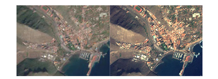
IDECanarias has published a new WMS service (Sentinel 2 Super-Resolution). The new satellite images published has been generated taken the original Sentinel2 satellite images (related to the Copernicus European project), and applying an AI-based algorithm to improve significantly their resolution and visual quality.
On IDECanarias viewer, we can compare the 2016-Sentinel2 image of 10 meters/pixel resolution without any treatment (native resolution), with the 2017-generated new image with improved 5 meters/pixel resolution obtained by using an AI super resolution algorithm. We can use the double window tool to create the comparison between both of them, click here.
The problem of images resolution improving is known as Super-Resolution, and its data input can be a set of images or just one (as in this case). Traditionally, this problem was resolved using of interpolation technics (interpolación bilineal, bicúbica, lanczos). Nowadays, with the arriving of the new Deep Learning algorythms, the artificial neural networks already trained to this issue, achieves far greater results than traditional techniques because of its ability in the contextualization, analysis and patterns recovery.
In this case, we have trained a deep neuronal network of 18 layers in order to increase the resolution of the Sentinel2 satellite images, from the sensor’s previous 10meters/pixel resolution to the 5meters/pixel one. This process means to multiply by 4 the number of pixels of the obtained image, which it gets an improved perception and better visual quality.
For those interested, the way to teach an artificial neural network to improve the image resolution is to take a better quality image as its point of departure (for instance, the Regional Orthophoto of the Canary Islands), and re-pixelate it with the desired resolution to be shown in the network. Therefore, we take the regional orthophoto and re-pixelate it to 5meters/pixel resolution and 10meters/pixel one, and then we train a deep convolucional neural network in order to learn how to restore the quality resolution of a degraded image (the 10m/pixel one) to its former greater resolution one (5m/pixel resolution).
We create more tha 200.000 sample patterns of all the islands and train/eval the network till the learning level would be satisfactory, also checking several net arquitectures and parameters. Once it has been finished, we can introduce the Sentinel2 satellite images of 10 meters/pixel resolution, and the network will apply its knowledge to restore the image to a 5 meters/pixel output resolution.
It is worth to point out that the chosen network arquitecture guarentees a coherent result within the input, avoiding the creation of false details that are not in the original image’s information. GRAFCAN continues working on some investigation lines related to artificial intelligence and territory, whose progress we will publish here.
Image segmentation using deep learning for agriculture uses
We have started a new project about image segmentation using deep convolutional neural networks in order to extract land uses from the images (including agricultural uses). We have developed and trained different network architectures with several image sources to evaluate the results (Ortophotos, Sentinel-2 and combined with Lidar data). This is a very successful line of work and we want to continue working in this technology by improving our pattern database, testing different network architectures and developing an entire framework to automatically process aerial images.
In the past, we have developed several projects using classical remote sensing tools to extract information from remote sensors but now we are able to check (as other papers show) that the new artificial intelligence techniques are more powerful to extract information from remote sensors. This is the reason why we are focusing our efforts on this new field implementing the latest advances.
Examples of network training process:
Example of segmentation on aerial images extracting different types of land use (including agricultural uses):
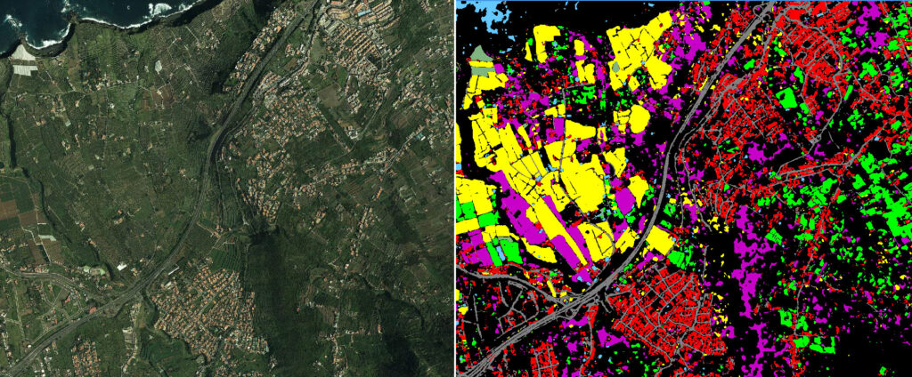
![]()